This page enables you to search for some of the best places to see wildlife in Leicestershire and Rutland. It's not comprehensive but we will keep adding new sites as we find more suitable sites. If you have a favourite site that you would like to see added, let us know. Did you know we can also set up Wild Place pages for private sites such as gardens, farms and company grounds? More about Wild Places.
To explore the Wild Places of Leicestershire and Rutland:
zoom into the map and click on any site to show its details below
use the filters below to find sites in your district or parish
type any part of the site name to search for a particular site
Just click on APPLY when you have entered your selection. Alternatively you can browse the full list below.
Key:Wild Places (outlined in orange); Public Rights of Way (green); county boundaries (blue), parish boundaries (lilac)
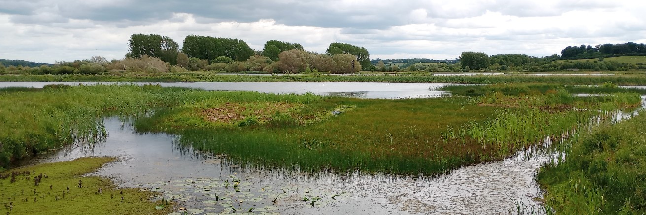
The main route of the Grand Union Canal, built between 1793 and 1814, is from London to Birmingham but it has several 'arms' including that which runs to Leicester and beyond into Nottinghamshire. This is a navigable route and has a public footpath (towpath) along the full length. As with most canals, the shallow water (typically around 1.2m) and shallower edges provides good habitat for emergent aquatic vegetation, which in turn supports a wide range of invertebrates.
The main route of the Grand Union Canal, built between 1793 and 1814, is from London to Birmingham but it has several 'arms' including that which runs to Leicester and beyond into Nottinghamshire. This is a navigable route and has a public footpath (towpath) along the full length. As with most canals, the shallow water (typically around 1.2m) and shallower edges provides good habitat for emergent aquatic vegetation, which in turn supports a wide range of invertebrates.
The main route of the Grand Union Canal, built between 1793 and 1814, is from London to Birmingham but it has several 'arms' including that which runs to Leicester and beyond into Nottinghamshire. This is a navigable route and has a public footpath (towpath) along the full length. As with most canals, the shallow water (typically around 1.2m) and shallower edges provides good habitat for emergent aquatic vegetation, which in turn supports a wide range of invertebrates.
The main route of the Grand Union Canal, built between 1793 and 1814, is from London to Birmingham but it has several 'arms' including that which runs to Leicester and beyond into Nottinghamshire. This is a navigable route and has a public footpath (towpath) along the full length. As with most canals, the shallow water (typically around 1.2m) and shallower edges provides good habitat for emergent aquatic vegetation, which in turn supports a wide range of invertebrates.
At just 1.6km long, the Welford Arm transports you from the Leicester Line of the Grand Union Canal to the picturesque village of Welford. It lies just south of Husbands Bosworth and near to the county boundary.
The main route of the Grand Union Canal, built between 1793 and 1814, is from London to Birmingham but it has several 'arms' including that which runs to Leicester and beyond into Nottinghamshire. This is a navigable route and has a public footpath (towpath) along the full length. As with most canals, the shallow water (typically around 1.2m) and shallower edges provides good habitat for emergent aquatic vegetation, which in turn supports a wide range of invertebrates.
Mill Field Wood lies adjacent to the canal - a Woodland Trust site with good access.
This former railway line was part of the Great Northern and London and North Western Joint Railway which opened between 1879-1883 to transport iron ore, agricultural produce and passengers.
This verge is being managed to improve biodiversity as part of the County Council/Parish Council verges biodiversity trial. It was surveyed in 2021 by NatureSpot volunteers but we would welcome additional wildlife records from the community, whether plants, animals or fungi.
Hambleton St Andrew's church is located at the highest point of the Upper Hambleton peninsula, which extends into Rutland Water from the west. The village is perched on high ground and surrounded on three sides by the waters of the reservoir. Most of the church, built from local Barnock stone, dates from the 12th century, but some Norman features can be found.
A band of deciduous woodland along the west-facing scarp slope of the Vale of Belvoir. It is a Site of Special Scientific Interest (SSSI) due to its colonies of Wild Daffodil Narcissus pseudonarcissus. The woodland covers about 18 hectares and is dominated by Ash and Sycamore with some Pedunculate Oak, Hawthorn and Elder. At the southern end is a small area of species-rich grassland and there are springs at several points at the base of the slope.
The Wildlife Area has been developed from several disused allotment plots and includes a wide range of habitats, including a wildlife pond. A number of apple trees are also present.
The verge lies at the south-western end of the village on Shepshed Road just outside the allotments. It is approximately 3 meters wide and is bisected in the middle by the allotment entrance. A tarmac footpath borders the inside boundary with a further narrow section of grassland leading to a mature hedge.
This 15 acres site has recently been planted with 14,000 native and naturalised trees. Planting was supported by the Forestry Commission and Hathern Parish Council. Planting sessions involved the local community.
The project will contribute to Charnwood Borough Council’s commitment to become Carbon Neutral by 2030. It is estimated that after 30 years the Hathern Community Woodland has the potential to capture up to 1,323 tonnes carbon dioxide.
There are two meadow areas in the churchyard which were established in 2012. They were seeded with Yellow Rattle and other meadow plants. The meadows are now self-sustaining and are cut annually in Autumn and the cuttings removed.
This area lies at the centre of the 200 square mile National Forest. Formerly coalfields it has been transformed into an attractive, wooded landscape. The Black to Green project, run jointly by the National Forest and the Wildlife Trust, is working to engage the local community in managing this area and recording the wildlife on its many sites.
Heather Wood is a young broadleaved woodland planted in the early 2000s with a range of native species. Dominated by Hazel, Ash and Field Maple with mature English Oak, the trees surround large open meadows. The River Sence runs through the bottom of the woodland.
Hicks Lodge and Newfields are former coal mining sites that have been totally transformed by landscape reclamation projects. Along with Shellbrook Wood and surrounding areas, these sites offer some of the most ecologically interesting habitats found within the Heart of the National Forest.
Highway Spinney is a semi-natural woodland and was designated a Site of Importance for Nature Conservation (SINC) in 1999. It lies at the edge of Leicester and is separated from its sister woodland, Meynell's Gorse, by Hinckley Road. Conservation work is undertaken by the Friends of Highway Spinney, supported by Groundwork Leicester and Leicestershire.
This old granite quarry is now managed as a nature reserve. Part of the site is flooded and this is securely fenced off. It is one of the highest points in Leicestershire and offers good view across Markfield and towards Leicester. Its developed was funded by Leicestershire County Council FLAG and Shire Grants and National Forest tree planting grants.