Wild places

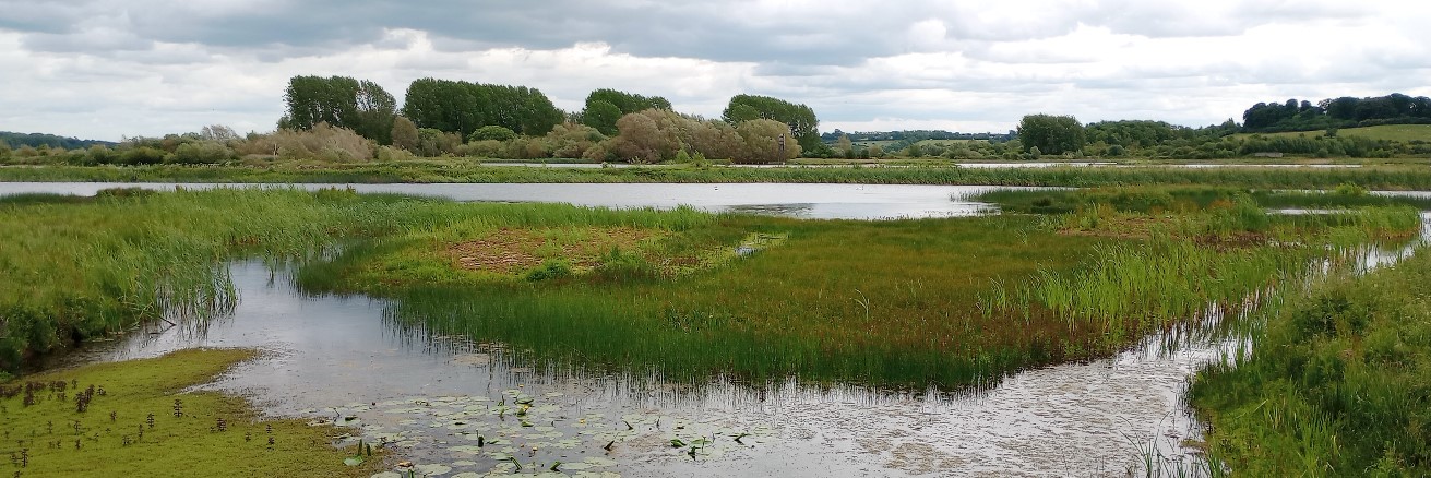
NatureSpot features over 500 sites across Leicestershire and Rutland as Wild Places. These showcase many of the best places to see wildlife in our area. Each Wild Place page displays the records and images submitted for that location - which update automatically as additional records are received. A full species list for each site is also available.

Private Wild Places

By arrangement, we can set up Wild Place feature pages for private gardens, grounds, farms, estates and other areas without public access. These work just as any other Wild Place page except they are not included in the menus and maps and are only viewable using the private URL provided. We ask for a donation for setting up a private Wild Place - the amount is up to you! Get in touch if you are interested by emailing info@naturespot.org

New Wild Places?

If you know of a site with wildlife interest that could be featured as a Wild Place page then let us know. Wild Places should meet the following criteria:

  • must either be entirely in public access (such as a Country Park), or have a public right of way (PROW) through them or adjacent to them from which the site can be viewed OR the landowner has given consent for the land to become a Wild Place. (A PROW as defined by the Highways Authority: in Leicestershire; in Rutland). 
  • must consist largely of existing habitats of significance to wildlife - e.g. woodland, wetland, watercourse, heathland, open mosaic habitats, unimproved/semi-improved or species-rich grassland, parkland, orchard, scrubland.  Sites which consist mainly of arable and cultivated land or just improved grassland are not suitable as Wild Places. (See Leicestershire's Biodiversity Action Plan and the Leicestershire and Rutland Local Nature Recovery Strategy).

Please note that NatureSpot's designation of a site as a Wild Place does not confer any legal or protected status to the land, and has no weight within the planning system. Neither does it confer any additional public rights of use or access to the land.

Explore Wild Places

To explore the Wild Places of Leicestershire and Rutland:

  • zoom into the map and click on any site to show its details below
  • use the filters below to find sites in your district or parish
  • type any part of the site name to search for a particular site

Just click on APPLY when you have entered your selection. Alternatively you can browse the full list below.

Key: Wild Places (outlined in orange); Public Rights of Way (green); county boundaries (blue), parish boundaries (lilac)

Covering an area of 4.96 ha (12.26 acres), The Blackberry Wood lies on the outskirts of the hamlet of Farm Town. It was planted in 2007 as part of the National Forest and contains a variety of young native trees bounded by mature hedges. The site offers some good views of the surrounding area.

Designated a Local Wildlife Site in 2006, The Drift verge at the Pickworth end is approximately 1,600 metres in length, on both sides of the track, varying between 1.5 and 2.5 metres in width. The main habitats are mesotrophic, calcareous and mixed grassland.

Designated a Local Wildlife Site in 2006, The Drift verge at the Ryhall end is approximately 2.2 kilometres in length, on both sides of the dirt track. The main habitats are mesotrophic, calcareous and mixed grassland on the south side, and calcareous and mixed grassland on the north side.

The Drift is an ancient track that follows the boundary between Lincolnshire and Leicestershire, forming part of the modern long distance footpath known as The Viking Way. A section of The Drift between the A607 and Saltby airfield is part of a Site of Special Scientific Interest (SSSI), designated because it is one of the best remaining examples of limestone grassland in Lincolnshire. Lowland calcareous grassland is rare throughout Europe and is ecologically rich in a range of plants and insects not found elsewhere.

Designated a Local Wildlife Site in 2009, the verge is 318 metres in length and 3-4 metres wide between the road tarmac and the Freewards woodland edge (on the eastern side of the road only). The main habitat is mesotrophic grassland and reportedly reasonably species diverse. The site is shaded at the north end, and partly shaded along the southern section.

This small woodland, possibly ancient, lies just south of Essendine. It was named as Freewards Thorns on the 1st edition O.S. map.

The Miles Piece covers 0.7 ha and is owned by the Leicestershire & Rutland Wildlife Trust. Donated to the trust in 1978, this is the smallest of their reserves (roughly the same size as a football pitch). This is a tranquil spot alive with birdsong in a sea of agricultural fields.

The site was previously orchards and allotments which were decommissioned and allowed to grow wild for some time.  Since 1985 the site has been in some form of conservation management with a number of organisations taking on this role.  Currently it is being managed by the City Council’s Leicester Environmental Volunteers and Parks Services.
The site is designated as a Local Nature Reserve and also a Local Wildlife Site due to the rich mosaic of woodland, scrub and grassland.

The Outwoods is 110 acres of ancient woodland to the south of Loughborough and is one of the oldest surviving woodland sites in Charnwood. Classed as an Ancient Woodland, the Outwoods supports a rich variety of plants, insects and birds typical of such old woodlands. Wet Alder and dry Oak/Birch woodland is interspersed with blocks of conifer planting, evidence of the extensive clear felling and commercial replanting which took place in the 1940's.

The Seek is new native woodland covering 10.83 hectares on the eastern edge of Braunston-in-Rutland, 1 mile south-west of Oakham and Rutland Water and has panoramic views over surrounding countryside. Prior to planting the area was arable land, which is still the dominant land use in the locality. There is a small stream which runs along the eastern boundary of the wood, leading in from the SE, providing a ribbon of riparian shrubs and trees.

This site is an area of unimproved grassland with stands of sedge situated alongside the River Soar. It also features hedgerows, ditches and boggy ground including a previous water course.  The fields are the core area of what was once a larger Aylestone Bog, part of which is now buried under the playing fields to the west. It is maintained through grazing by English Longhorn cattle during the summer months.

Designated a Local Wildlife Site in 2005, the Green Lane verge includes both sides of the road, with the southern side 511 metres in length, and the northen side 632 metres in length. The verges are 1-5 metres wide, and the main habitat is mesotrophic grassland.

Designated a Local Wildlife Site in 2003, the New Road verge stretches for 1.3 kilometers on both sides of the road. The main habitats are mesotrophic grassland, calcareous grassland and mixed grassland. The verge is reported to be species-diverse.

Thomas Estley Community College is located in the centre of Broughton Astley village, serving 11 - 14 year olds. TECC is a modern school with a large green space, used mainly as playing fields but with a few mature trees and hedges along some its boundaries. We have included TECC as a Wild Space because of the special interest by the staff and pupils in learning more about the wildlife on their site and their support for the Broughton Astley NatureSpot development.

These meadows are long-establish and unimproved meadows which are being restored through an appropriate mowing regime. The Leicestershire Round footpath cuts across the site. A playground and multi-use games area have been built in part of the site and the north-east corner has been flattened as a football area. However the surrounding meadows are wonderfully rich.

Owned by Severn Trent Water, Thornton Reservoir was opened to the public in 1997. Excellent for bird watching with good access via the circular walk around the reservoir.

The churchyard of St Mary the Virgin Church is central to the village and provides the setting for the prominent grade 2 listed church on the hilltop. The trees around the churchyard perimeter offer a sense of seclusion, although the adjacent A607 is an intrusion on the tranquil setting. The churchyard provides a central focus for a village divided by the busy road. It is a valued community and heritage space with good accessibility and visibility.

This verge is being managed to improve biodiversity as part of the County Council/Parish Council urban verges trial. It was surveyed in 2020 by NatureSpot volunteers.

A large area of the verge on one side of the road had been dug, levelled and reseeded prior to the 2020 survey so only the remaining untreated area was surveyed. Here the floral diversity was reasonable and with a few species found in quality grassland. Species of note include Crested Dogs-tail and Smaller Cats-tail.

This verge is being managed to improve biodiversity as part of the County Council/Parish Council verges biodiversity trial. It was surveyed in 2021 by NatureSpot volunteers but we would welcome additional wildlife records from the community, whether plants, animals or fungi.