

Welcome to Enderby
Welcome to the Enderby NatureSpot page which gives local residents the opportunity to find out about, and contribute to, our knowledge of the wildlife in the parish. Just click on the headers of these stories to read more.

Selected parish/ward / Wild Places / Footpaths / Parish/ward boundaries
To find out more about local Wild Places (red boundaries on the map), visit the Wild Places page. Contact NatureSpot if you have an idea for any additional Wild Places.
The parish has a long history with iron age finds indicating an early settlement. The village of Endrebie (now Enderby) is listed in the Domesday Book in 1086. The parish borders the south of Leicester City and is next to junction 21 of the M1 and Fosse Park. The parish borders the River Soar to the east with good public access to the river and surrounding wildlife habitats.
Parish/ward species count:
Enderby Parish Council

We need more wildlife observations from the parish. So, if you've seen a species you recognise, from a Blue tit to a Bluebell, click on the header to find out what to do.
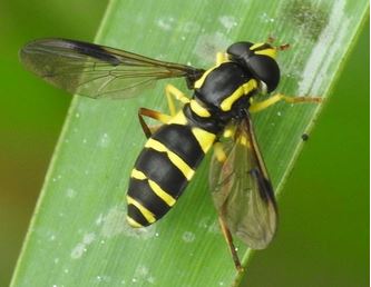
Many harmless hoverflies mimic wasps by adopting the familiar yellow and black stripes but few are as spectacular as this one. Xanthogramma pedissequum doesn't have a common name, which is a shame for such a striking insect. This one was found in the parish near to Fosse Park.
The images and records below are all from the parish/ward and have been submitted by members of the public.
The latest images and records displayed below include those awaiting verification checks so we cannot guarantee that every identification is correct. Once accepted, the record displays a green tick.
In the Latest Records section, click on the header to sort A-Z, and again to sort Z-A. Use the header boxes to filter the list.